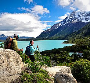
Come and see the beautiful landscapes of La Araucanía, where you can visit the Volcano Llaima, lakes and lagoons of volcanic formation. It is an ideal place to concect with nature under the great araucarias that presents the place.


Conguillío National Park has a surface area of 60.832 hectares, and in Mapudungún its name means 'water with pine kernels'.
Some of its greatest attractions are ‘Llaima’ Volcano (3,125 meters, 10,250 ft), its lakes and lagoons of volcanic origin, and the ancient forests, many of which are unexplored. This park is also known as ‘the umbrellas’, due to the shape of its ancient araucaria forests.
Location: Región de la Araucanía, 148 km (92.5 mi) northeast of Temuco. Curacautín is located 28 (17 mi) km northwest.
When to go: Year round.
Opening hours: High and low season: from 8:30 to 18:00 from Mondays to Sundays.
Climate: The park has two types of climate: warm- temperate with less than four dry months and ice, high climate. The former is present in lower areas, with maximum temperatures of 6º and 15ºC in June and January respectively, frequent frosts between May and October, precipitations ranging between 1.500 and 2.500 mm a year, and snow reaching up to three meters in winter. The latter type of climate is present above 1.400 mts, where the temperatures are below 0º both in winter and summer, and precipitation indexes reach 3.000 mm.
Picnic Areas: In the concession area there are 4 picnic sites.
Food: There is a store in the ‘Curacautin’ beachr, where you can buy essential food products.
Ski Center: Las Araucarias Ski Center is located on the slopes of Llaima Volcano. It has chair lifts and refuges.
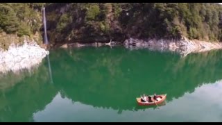
Other facilities: There is a cafeteria, a store, first aid service, bakery and boat rental.
What to see:
Conaf has combined its efforts with private interests to preserve and protect this area, turning Congullío into an ideal park. Not only will you enjoy the park's beautiful surroundings, but also learn about its biological diversity thanks to the education and interpretation programs implemented by Conaf.
- Some of the park's attractions are Llaima Volcano, Sierra Nevada, and the rugged landscapes made up by great lava accumulations. Also, an important contribution to the landscape is its great forest mass, with araucarias and other remarkable species, as well as its lagoons with their pure, crystalline waters.
- There is an abrupt transition between vegetation and volcanic slags in Arcoiris lagoon. The road continues through the so-called "Moon Valley", which, just like its northern homonym, is dry and desolate but not as spectacular. In the distance you will see hills covered with vegetation and the spectacular Llaima volcano.
- Laguna Verde (Green Lagoon) and its green waters are drained through Truful-Truful river, which takes its name from the Truful-Truful waterfalls, located near the park's entrance.
- Even though spring and summer are the best seasons to visit the park, one of the main attractions in winter is Las Araucarias Ski Center, located on the west side of Llaima volcano. It has two chairlifts, a cafeteria, ski lessons, equipment rental, and accommodation in refuges.
Trails:
- Los Carpinteros Trail: in its 5 kms (3 mi) long, it passes through coihue, araucaria and lenga forests leading to Captrén lagoon. It is a beautiful spot, but swimming or sailing is not allowed. In this trail you will see the beautiful "Araucaria Madre", a tree with a 2 mt diameter trunk.
- Sierra Nevada Trail: in its 10 kms (6 mi) you will see several types of forest varying according to their altitude. It also offers excellent views of Lake Conguillío, Llaima Volcano and some glaciers.
- Las Araucarias Self-guided Educational Trail: it is equipped with 12 stations offering information and photos in pannels. The trail passes through an araucaria forest. Duration: 1 hour.
- Las Vertientes Educational Trail: 800 meters (2,624 ft) long. Several underground water brooks spring up along the way.
- Cañadon del Truful – Truful Educational Trail: 600 meters (1,968 ft) long, a tour revealing the area's geological history.
- Cerro Colorado Educational Trail: 3 kilometers (1.8 MI) long. It bypasses the west side of the Llaima Volcano, alowing you to observe the Central Valley and its slag heaps.
Conguillío National Park Natural Heritage
Geomorphology: The park is located in the Andes and it has two main peaks: Llaima Volcano (3,125 meters - 10,250 ft. above sea level). Through the centuries, its two craters have hugely influenced the park's morphology with more than 70 historical eruptions. It is one of the most active volcanoes in South America and its two latest eruptions augmented its height in 70 meters. The second peak, the inactive volcano of Sierra Nevada (2.554 mts), has also contributed to originate lakes, lagoons, rivers, slag heaps and influenced the native flora and fauna. Other important peaks are Lorca and Sierra Santa Ester hills.
With a more recent origin (100-600 years) the bodies of water existing in the area were also created due to volcanic activity, when lave blockage impeded the free flow of the rivers, forming the current lake system. Some of the water sources are Lake Conguillío (780 ha) and the lagoons Captrén (5 ha, Verde (140) ha, and Arcoiris (0,5), all of which are part of the hydrographic basins of rivers Biobío and Imperial.
In general, rivers have exorheic systems. The most important streams are Captrén, Colorado, Blanco, Punta Negra, Lonquimay, El Manzano, Imperial, Allipén, Truful-Truful, El Tiuque, El Empedrado y Agua Enterrada.
Flora: According to Gajardo (1996), Conguillío National Park comprises two regions: Andean-Patagonian Forests in the subregion of Araucanía Mountain range; and region of Deciduous Forests, in the Deciduous Andean region. The former has High-Andean deciduous species, while the latter has mixed deciduous of the Andes. Even though these forests have the most impressive trees, there are some other very interesting species in the park. Coihues, oaks and evergreen beeches are found all over the park; some others, such as lengas, ñirres, hazel trees, maytens, cordilleran cypress and lleuques, are located in the Conguillio and Truful – Truful area.
Araucaria: Undoubtedly, the araucaria is the most important species in the park. There are areas, not easily accessible, where pure araucaria forests are almost 1,200 years old. This species is considered mature at 200 years old, and develops its characteristic ‘umbrella’ shape around the 500 years. After the larch tree, the araucaria is the second longest living tree in Chile.
The pine nut, its seed, is the base food or form of nourishment of the Pehuenche people (pehuen = araucaria or its seed, and che = people), who used to live only in areas where there were pehuén or araucaria trees.
Endangered Flora Species:
- Araucaria (Araucaria araucana)
- Cordilleran Cypress (Austrocedrus chilensis)
- Lleuque (Prumnopitys andina)
Fauna: In a park where the araucaria tree reigns, there lives a wide variety of animals as well. Among the predatory mammals, the pumas and foxes (chilla and culpeo), are the biggest; then we find the quique (a kind of weasel) and the güiña (type of wild cat). Among the birds, there is a wide variety of ducks, condors, "traros", eagles, and ringdoves.
Cultural Heritage
Conguillío National Park was declared a protected area in 1950.
Part of this recognition is due to the discovery of ten archaeological and anthropological sites in the surroundings of Lake Conguillío. This suggests that indigenous groups visited the area periodically to provide themselves with natural resources, especially wild fruits like pine seeds, which abound in the area. The activity of these groups was mostyl based in an agricultural subsistence, rather than on hunting activities.
The Pehuenches were the main gatherers in this area. It is a people with high seasonal mobility, that even today uses the pine for a variety of purposes.
Not only the objects found reflect the Pehuenche presence, but also the Pehuenche names for places and geographical accidents like "Llaima" (resurrected), "Conguillío" (water with pine seeds), and "Truful-Truful" (from waterfall to waterfall).
Gastronomía
This area has a gastronomic identity marked mainly by Mapuche cuisine and the complement of Spanish cuisine. This land is characterized as a place of cultivation, where there are different outbreaks of fruits, legumes, vegetables and spices that are fundamental in the condiment of the food as the Merquén.
Meat and fish are also important food, which are usually seasoned with the spices of Mapuche cuisine. Within the typical dishes are the Charquicán, empanadas with pebre, roast lamb, tortillas embers among others. You cannot visit this area without eating chestnuts or pine nuts.
A traditional drink of the area is apple chicha or wine. Desserts usually have blueberries or raspberries or nuts and chestnuts as well.
How to go
- Plane: From Santiago to Temuco.
- Bus: From Santiago to Temuco.
- Tours: From Temuco to Conguillío National Park.
For more information about prices press the next link: http://www.conaf.cl/parques/parque-nacional-conguillio/
Recommendations
The weather on this place is oceanic and rainy, with a bit of Mediterranean influence, there’s abundant and constant rainfall, even in summer. The annual average temperature is 11° C.
We advise you to wear clothes that are suitable for rain, because the weather is constantly changes at any time of the year.
Stores in rural areas are open all day, but they close between 13.00 and 15.00. We advise you to carry local currency (Chilean pesos), since it isn’t possible to pay with debit or credit cards in kiosks and rural stores.
Do not litter on parks or streets. Taking care of our environment is everyone's responsibility. Avoid fines by following the rules.