- Home
- Destinations
- Central Valley, Vineyards & Santiago
- Colchagua Valley
- Rio Los Cipreses National Reserve
With a surface area of 36,882 hectares (81,140 acres), this reserve is the result of a combination of volcanic, glacial and fluvial phenomena. Its main riverbed is the ‘Los Cipreses’ river, which is an affluent of the Cachapoal river, but there are also small lagoons in the highest zones of the park, such as the ‘Agua de la Vida’ lagoon.


With a surface area of 36,882 hectares (81,140 acres), this reserve is the result of a combination of volcanic, glacial and fluvial phenomena. Its main riverbed is the ‘Los Cipreses’ river, which is an affluent of the Cachapoal river, but there are also small lagoons in the highest zones of the park, such as the ‘Agua de la Vida’ lagoon.
Created in 1985, this reserve is now part of a CONAF program trying to boost the development of ecological tourism in the protected wild areas of Chile, encouraging the participation of the private sector in the construction and operation of infrastructure, and the development of ecological tourist services through the concession system.
The best time to visit the park is between September - December and mid February - April, due to good weather and fewer visitors. However, if you want to see the impressive snowy landscape, the best time is between June and July.
Created with the aim of protecting and maintaining representative samples of the biological diversity of the zone and its habitats, ‘Río de los Cipreses’ is the home of endangered species or species being reintroduced. There are also, however, places with archeological, anthropological and historical interest, for example, the petroglyphs and old constructions.
Río Los Cipreses National Reserve Basic Information
Location: Región del Libertador General Bernardo O’Higgins, 50 kilometers (31 mi) east of Rancagua.
How to get there: From Santiago-Rancagua: by public or private transportation. From Rancagua to the reserve: take the highway ‘Presidente Eduardo Frei Montalva’, or also called ‘the copper highway’ to the east. After 50 kilometers you will get to the mining village of Coya; continue until the crossroad and take the road signaling toward the reserve. After 15 kilometers you will arrive at the porter’s lodge.
When to go: Year round.
Climate: Mountain warm with 4 dry months, it is hot in the summer, with a rainy and snowy winter. The average annual precipitation ranges from 800 mm in low lands to 1,500 mm (31 and 59 in.) in the higher places. The maximum average temperatures in the zones of low altitude range between 19ºC and 21ºC (66º and 70ºF), and the minimum temperatures range from 5ºC to 7ºC (41º to 44ºF).
Services: Picnic areas, CONAF, accommodation, transportation, trails.
Rates:
- Adults: CLP 2.700.
- Children (6 to 12 year old) and elderly: CLP 800.
Río Los Cipreses National Reserve Infrastructure and Services
Administration office: it is located at the entrance of the reserve. The telephone number is (072) 297505.
Park Ranger’s Office: Located in the administration area.
Dining and camping areas: Ranchillo’ picnicking area, 6 kilometers (4 mi) from the administration, has 23 sites but minimal infrastructure. There is a provisory camping area maintained in this place, since the ‘Maitenes’ area is closed due to problems that originated from the 1993 landslide.
Refuges: Rustic Refuges: ‘Urriola’ refuge, located an estimated 20 kilometers (12 MI) from the ‘Maitenes’ sector, and 32 kilometers (20 MI) from the administration.
From the ‘Maitenes’ area there is a path suitable for both walking and horseback riding, leading into the Cipreses’ valley. The refuge is located at an approximate altitude of 1,500 meters (4,920 ft. above sea level). It takes approximately 5-6 hours walking, and 4 hours riding.
Accommodation: The nearest private facility is the hotel ‘Termas de Cauquenes’, which was established because of high tourism to the hot springs. It is 15 kilometers (9 MI) before arriving to the reserve.
Horseback riding Excursions: It is possible to carry out excursions on horseback to camping areas and beyond, but riding inside the reservation requires the appropriate authorization from Conaf. Interesting places to visit are the ‘Carrizal’ and ‘Urriola’ sectors, as well as the ‘Piuquenes’, ‘Agua de la Vida’, and ‘Agua de la Muerte’ lagoons.
Facilities outside the area:
- Gas: Rancagua - Coya.
- Telephone: Reserve administration (only local calls), Coya, 20 kilometers (12 MI) along a vehicular road, Rancagua (50 kilometers).
- First Aid: Ranger Corps of the reserve and Coya hospital.
- Food: Coya, Rancagua.
Attractions in Río Los Cipreses National Reserve
What to see:
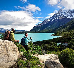
The natural phenomena which molded this wonderful landscape, have created contrasting features, which, along with the development of a diverse vegetation, makes the reserve a very attractive place to visit. The Andean landscape seems to go on forever, but perhaps the most distinct are the peaks of ‘El Indio’, ‘El Agujereado’, ‘Cotón’, ‘Palomo Volcano’, ‘Alto de los Arrieros’, ‘Los Punzones.’ Among the countless waterfalls, the most spectacular are ‘Ranchillos’, ‘Maitenes’, ‘El Relvo’, ‘El Indio’, ‘Cotón’, Los Pangues’, and ‘El Baúl.’ The lagoons ‘Los Piuquenes’, ‘Agua de la Vida’, and ‘Agua de la Muerte’ are other points of interest, which are not to be missed. And, if you still have time and energy, visit the glacier ‘Río Cipreses’, the valleys and brooks ‘Piuquenes’, ‘El Baúl’, ‘Los Arrieros’, and ‘Medina.’
What to do
- Swimming: in the following sectors: ‘Ranchillo’, ‘Maitenes’, and ‘Agua de la Vida.’
- Trekking: in all sectors of the park.
- Wildlife watching: in all the sectors of the park.
- Horseback riding: in ‘Maitenes’, ‘Urriola’, ‘Agua de la Vida’, ‘Los Piuquenes’ lagoon, and ‘Baúl’ brook.
- Watching and cultural tour: Sectors: ‘Agua de la Vida’, Glacier area, ‘Los Piuquenes’ lagoon, and ‘Baúl’ brook.
- Environmental information: in the administration area there is a museum and an information center.
Trails
- Los Peumos: it begins in the ‘Ranchillo’ picnicking area. It allows you to observe the vegetation dynamics, the area's geomorphology, the development of the landscape and the remains of mining activities, typical to this zone.
- Tricahues: located in Ranchillo. It has services for people with special need, and braille signs.
Other excursions can be carried out in the interior zones of the reserve, but require authorization from administration, who analyze the reasons for the trip and enforce the pertinent rules and regulations for use of the park.
Nature in Río Los Cipreses National Reserve
Geomorphology: The most important area is the Cipreses river basin, boasting a beautiful long and narrow valley, with a straight north - south orientation. The floor of the valley varies in altitude from 1,200 to 1,700 meters (3,936 to 5,576 ft) above sea level; the surrounding peaks vary from 3,000 to 4,900 meters (9,840 to 16,072 ft) (Volcano Palomo). There are also some smaller 'hanging' valleys, corresponding to the rivers ‘El Baúl - Piuquenes’, ‘Medina’ and ‘Los Arrieros.’
Hydrography: The hydra network of the reserve is formed by tributaries of the Cachapoal river. The most important is the ‘Los Cipreses’ river, whose basin makes up 80% of the reserve, and which originates in the southern point of the reserve. Other rivers and brooks are ‘El Torno’, ‘El Relvo’, ‘Rapiante’, ‘El Baúl’, ‘Piuquenes’, ‘El Arriero’, ‘Medina’, and ‘El Colorado.’ There are also lagoons higher up among the mountain peaks; these are: ‘Agua de la Vida’ (5,576 ft above sea level), ‘Los Piuquenes’ (7,544 ft), and ‘El Arriero’ (7,544 ft).
Flora: The basin of the river ‘Los Cipreses’, found in a large mountain valley, has a variety of vegetation ranging from the sclerophyllous forest (adapted to semi desert conditions) composed by peumos, soapbark trees, and litris. Further up, there are some plant species that grow in areas over 2,000 meters (6,560 ft) high.At medium heights, it is possible to find patches of Andean cypress forests growing beside the terebinth, especially in the Urriola sector. The inferior vegetation stratum of this zone is made up mainly of broom sedge, and in springtime, the flowers bloom beautiful colors.
Fauna: Birds and animals present in this zone are remarkable not only for their majesty, but also for how well preserved they are. The guanaco dwells among the most inaccessible slopes; the red and grey foxes, can be easily observed in public places; and the vizcacha, which resides in rocky places. The burrowing parrot is an important species found here. This bird, which is an endangered species, builds its nests along the cliffs of the Cachapoal river, and can be seen in the morning when they set out for food and in the evening when they return to their nests. Near the higher peaks of the mountains we can see condors and eagles, and in the lagoons and brooks, the Magellanic caiquén, the correntino duck, and the cachañas (small parrots).
Cultural heritage
In the reserve, you can see petroglyphs made by ancient Indians in the following places: Carrizal (Cachapoal), Piedra de Indio, Cotón, Agua de la Vida, Rincón de Los Guanacos, ‘El Baúl’ and ‘piuquenes’ brooks, and Cajón de Los Arrieros.
Between the years 6,000 and 3,500 BC, small groups of hunters moved from the Pacific Ocean to the eastern slopes of the Andean Mountain Range, taking advantage of a warmer period of time to hunt guanacos and huemuls (the latter extinct in this zone). Later, these groups adapted to the climatic conditions and established themselves in this place after certain technological changes in their hunting instruments. It is believed that these men created the art of petroglyphs.
'Piedra de Indio' Petroglyph
The house, park, storage, and corrals of the former Chacayes ranch, dating back to the end of the 19th century, are located here. Underneath the house lie the remains of ancient ironworks built in the 17th century by Jesuits.
The area called ‘Paso de la Guardia’ is part of the folklore and legend of the area. It is named after the narrow natural bridge over the Cachapoal river, which carried the Pincheira brothers across the river to find shelter in the mountain valleys of this reserve.
Recommendations
The climate is Mediterranean, hot in summer and cold in winter. The average annual temperature is around 13° C. The central zone of Chile is considered the warmest of the country. In summer temperatures surpass 30 ° C.
Stores in rural areas are open all day, but they close between 13.00 and 15.00. We advise you to carry local currency (Chilean pesos), since it isn’t possible to pay with debit or credit cards in kiosks and rural stores.
Do not litter on parks or streets. Taking care of our environment is everyone's responsibility. Avoid fines by following the rules.