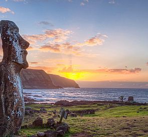
Rapa Nui National Park is world heritage, is buzzwords with Conaf, from the year 2016 and the community Ma'u Henua. This has more than 7,000 acres with endless cultural and natural landscapes.


Thanks to its cultural and natural value, Rapa Nui National Park was declared a World Heritage Site by UNESCO in 1995. The park protects not only places of natural beauty, but also the misteries of pascuense people, which has fascinated the world with its great, intriguing cultural manifestations. In its 7.130 hectares, natural and archaeological sites merge in wonderful communion.
Location: Region of Valparaíso. Pacific Ocean, 3.700 km west of Caldera. Hanga Roa is next to the park.
How to get there: By plane, only with LAN, from Santiago, 7 flights a week. There are also cruises that take the Polynesia and stop in Easter Island, staying for 1-3 days. The ships of the Chilean navy go there once a month.
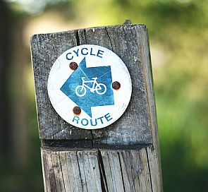
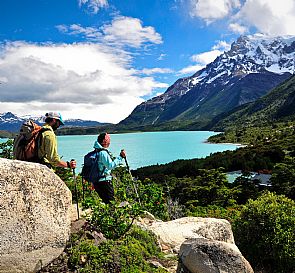
Inside the park, there are places like Poike and Maunga Terevaka, which can only be reached by horse. The rest of the island can be covered by vehicle, preferably a 4WD, bike, horse and foot. There are several tourist packages that take you to the area for half or a full day, accompanied by tourist guides.
When to go: Year round.
Climate: Sea climate, subtropical with rain all year.
Services: Accomodation, park rangers, transport.
Infrastructure and Services
Administration Office: Located in the Orongo area, this is the place where you buy your entrance ticket. You can also find printed information.
Park Ranger's post: There are two posts: one in Rano Raraku and other in Anakena.
Meals and basic services: Rano Raraku and Anakena are the only places with restrooms and barbecue areas. Nevertheless, camping inside Rapa Nui National Park is forbidden.
Accommodation: Outside the park there is a good accommodation offer, ranging from hotels and cabins, to small residences run by Rapa Nui families.
Food: You can buy food from the local shops with a great variety of products.
Services outside the area:
- Police Station: only in the town of Hanga Roa.
- Gas Stations: only in Hanga Roa, near the airport.
- Food: in Hanga Roa you will find empanadas, sandwhiches, and a whole variety of products.
- First Aid: Hanga Roa hospital has equipment, facilites, and qualified personnel. The emergency numbers are 100215 and 100217
- Means of transportation: there is a wide variety of vehicles for rent, including four-wheel drive, motorbikes, bicycles, and horse rental. You can also take private taxis in urban areas, which for a reasonable price take residents and tourists to the park's different areas.
Rapa Nui National Park has paved roads that connect all the south coast. Although they are not in the best conditions, the road connecting Hanga Roa and Anakena is in perfect state. The north area is connected by unpaved roads, which are in average conditions.
Currently there are tour operators, carrying out full-day and half-day visits to the different areas of the park.
Attractions in Rapa Nui National Park
What to see:
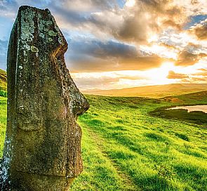
Compared to other parks and reserves, Rapa Nui is not special in terms of the vegetation, yet its beauty lies within its volcanic origin, its oceanic setting, and its mysterious history and monuments. The main attractions are the Rano Kau (crater with lagoon inside and native vegetation), Anakena (restored Ahu, beach and picnic area), Ovahe (pink sand beach) and Maunga Tere Vaka (highest point of island).
What to do:
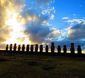
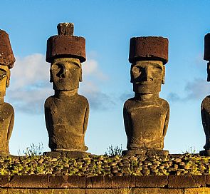
- Archeological Interests: the following areas are the richest in this respect: Puna Pau, Rano Raraku, Anakena - Ovahe, Ahu Akivi, Costa Norte.
- Panoramic Views: Puna Pau, Rano Raraku, Anakena - Ovahe.
- Horseback Riding: Costa Norte.
- Photography: particularly the areas of Puna Pau, Rano Raraku, Anakena - Ovahe, Ahu Akivi, Costa Norte.
- Swimming and diving: Anakena - Ovahe
- Surfing: Hanga Roa
Trails in Rapa Nui National Park:
- Currently open:
- Vinapu
- Ahu Akapu
- Vaihu
- Akahanga
- Tongariki
- Te Pito Kura
- Ahu Akivi
- Ana Kai Tangata
- Ana Ka Kenga
- Ana Te Pahu
- Lookouts:
- Orongo
- Rano Kau
- Recreational:
- Ovahe
- Anakena
- Interpretive:
- Orongo-Aldea (0,9 km.)
- Tahai (0.4 km.)
- Rano Raraku (1,5 km.)
- Papa Tataku Poki
- Papa Vaka (0,2 km.)
- Puna Pau (0,4 km.)
- Trails:
- Te ara o te ao (6,3 km.)
Natural Heritage in Rapa Nui National Park
Rapa Nui is a triangular-shaped island of volcanic origin, created by the action of three main volcanoes: Terevaka, Katiki and Rano Kau. The island is actually the peak of an enormous submerged mountain with a circumference at its base of 200 kilometers (125 mi) and around 4000 meters (13,120 ft) in altitude.
The topography of the island is undulating, with smooth slopes and numerous volcanic cones, distributed across its surface.
On the island there is no surface running water and the underground water sources are found at a medium depth. The only three surface water deposits are on the Rano Aroi, Rano Kau and Rano Raraku.
Flora:
Flora and vegetation on the island are scarce. In the prairies you can find Giant Rat's Tail Grass and koda millett, accompanied by shrubs of tropical guava, wild sunhemp, and bush lupine. There are also some forests, where the predominant varieties are Eucalyptus, Mellia azedarach and silk trees. The native species are concentrated in several areas, one of which is the crater of the Rano Kau volcano, where you can see mako'l, mahute, ngaoho, hau hau and some ferns. In some places of Hanga Roa and in the vicinity of CONAF there are toromiro trees, an endemic species which CONAF is trying to reintroduce to the island's ecosystem. Vegetal formations cover 90% of the island's surface, arboreal formation and plantations occupy 5%, bushes 4%, and the remaining 1% corresponds to very sparce vegetation in eroded areas, rocky places, and urban areas.
- Forests and plantations: mainly Melia Azedarach and Albizia Julibrissen. Plus, there are several copses across the island, mainly formed by pikanos (Eucalyptus globulus). The structure of these copses is contemporary and monostratified, pure formations with no understory and with a herbaceous layer dominated by Here hoi (Sporobolus africanus). In the Rano Kau plantations, the endemic species mako'i (Thespesia pupulnea) has also been used, and in Anakena there is a small plantation of cocos nucifera, which are important for the their aesthetic value.
- Scrubland: the bushy formations are not too varied, the predominant species being tuava (Psidium guajava), Crotalaria sp, chocho (Lupinus arboreus), vine, mahute (broussonetia papyrifera), and Dodonaea viscosa. The three latter species are located in Rano Kau, Lupinus arboreus in Hanga Roa, and Crotalaria sp. in Hotu Iti. Tuava (Psidium guajava) is the bush of largest distribution in the island. It is associated to a large number of species, most commonly the toroco herbs, here hoi, heriki hare and Crotalaria sp.
- Prairies: according to Michea, the dominant species in the prairies is here hoi (Sporobolus africanus), which can be found on its own or sharing the habitat with other species. Heriki hare (Paspalum scrobiculatum) is also present in areas with low or medium altitude, where it is associated to the Sporobolus Africanus. In turn, Sporobolus africanus is present in high areas or Terevaka. Other important species are Erigeron linifolius, Euphorbia hirta, and Euphorbia serpens.
Fauna
The laund fauna in Easter Island is not too diverse, unlike in other polynesic islands. Some important species are the small lizards called Gekkonidae Lepidodactylus lugubris (moko uru-uru kau) and Ablepharus boutoni poecilopleurus (moko uri uri). Occasionally you can find the green tortoise (Chelonia mydas) and carey turtle (Eretmochelys imbricata bissa). Important sea birds are kena (Sula dactylatra), tavake (phaeton rubricauda), makohe (Fregata minor), kakapa (Pterodroma arminjoniana), and kuma (Puffinus nativitatis). There are also small seagulls like the grey-backed tern and kia kia (gygis alba), which are part of the Tangata Manu tradition.
Geology and Geomorphology:
Easter Island is a volcanic, oceanic island of recent age, structured by a complex effusive cycle, which culminated in the formation of several eruptive centers. These, associated to the eruptive processes in the sea have given the island its current morphologic traits. The main eruptive centers are Poike, Rano Kau, and Terevaka, the latter reaching 511 above sea level. The island has an undulating topography.
Hydrography:
There are no superficial flows in the island, the underground waters are very deep, and cannot be used due to their high salinity. The only three water deposits are located in the craters of Rano Aroi, Rano Raraku, and Rano Kau.
Gastronomy
The typical food of the island is mainly based on marine products such as fish including tuna, mahi mahi, the sierra, and seafood such as lobster, shrimp along with other seafood which are only on the island. You are also consuming bananas, pineapple, sugar cane and sweet potatoes. This is a pretty healthy diet with much protein intake.
One of the most common dishes are the fried empanadas with tuna, Umu Rapa Nui or also known as Rapa Nui curanto, is well cooked fish and various types of seafood and potatoes in wood and stones that are covered by banana leaves. Another traditional dish is the Tunu, a preparation based on fish freshly taken from the sea cooked on hot stones on the shores of the sea.
Recommendations
The weather in Easter Island is tropical and cold, with mild temperatures throughout the year. The average annual temperature is 20.5° C. In winter the temperature is around 18° C the minimum and in summer, is around 23° C the maximum.
We advise you to bring cash with you is, since there aren’t many ATMs on the island.
DO NOT litter on the beach, parks or in public roads. Taking care of our environment is everyone's responsibility. Avoid fines by following the rules.